Old Westland/Chapter 3
Chapter III
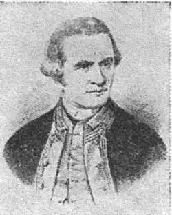
Cook
Captain Cook, during his second voyage round the world in the Resolution, sailed into Dusky Sound, on March 26th, 1773, and there established health recruiting quarters for his officers and men. The obtaining of fresh meat was his first consideration and as seals were to be seen in great numbers one was immediately killed and consumed. Having established himself Cook next proceeded to make a survey (and a very excellent survey, too) of Dusky. In this connection, Robert McNab, M.A., LL.B. one time Member of the House of Representatives, and Minister of Lands and Agriculture, in “Murihiku,” that incomparable contribution to literature pertaining to the southern portion of the South Island of New Zealand, states that the fact that Cook gave to the world information that here was a safe anchorage, where there was first-class timber for spars, and myriads of seals, put the southern portion of the West Coast of the South Island definitely on the map, so much so, that as early as 1793, the first sealing gang to visit New Zealand landed there, obtaining 4,500 skins which were sent to the China market; this, with the exception of a few spars obtained by casual vessels visiting the North Island, was the first shipment of any kind sent overseas from this Dominion and to the southern portion of the West Coast must go the credit thereof.
From 1803 sealing became very general and as showing the quantities then existent, comments on Australia by Sir Joseph Banks (whose name is perpetuated in Banks Peninsula), dated June 4th, 1806, were as follows: “The island of Van Diemen, the south-west coast of New Holland, and the southern part of New Zealand produce seals of all kinds in quantities at present almost innumerable. Their stations on rocks and in bays have remained unmolested since the creation. The beach is encumbered with their quantities, and those who visit their haunts have less trouble in killing them than the servants of a victualling office who kill hogs in a pen with mallets.”
With such a harvest awaiting the taking, many Australian and other overseas vessels made Dusky Sound their headquarters, operations extending in all directions, and to well within the southern boundary of Westland. As showing this to be so, the Rev. Richard Taylor, in his book, “New Zealand and its Inhabitants,” says: “From the evidence of a person who was formerly engaged in sealing at Dusky Bay, as far back as the year 1823, it appears that from 1826 to 1827 there was an almost constant succession of earthquakes, some of which were sufficiently violent to throw men down. At times he and his party, who then resided on a small island, were so alarmed lest it should be submerged that they put out to sea. There, however, they found no safety, but such was the flux and reflux of the ocean, that they were in the greatest danger of being swamped, and were thankful to get on shore again. The sealers were accustomed to visit a small cove called the jail, which was a most suitable place for anchorage, being well sheltered with lofty cliffs on every side, and having deep water in it close to the shore, so that they could step out from the rocks to their boats. It was situated about eighty miles to the north of Dusky Bay. After the earthquakes the locality was completely altered; the sea had so entirely retired from the cove that it was dry land. Beyond Cascade Point the whole coast presented a most shattered appearance, so much so that its former state could scarcely be recognised; large masses of the mountains had fallen, and in many places the trees might be seen under the water.”
It is of great importance to note that Cascade Point is 30 miles north of Westland’s southern boundary, and that the sealing grounds extended much further in that direction, and in particular that only men who had “worked” that part of the coast for seals and were familiar with it could describe it with such a wealth of detail; and thus is established the outstanding fact that at least 116 years ago Westland contributed its quota of seals to the many gangs engaged in the industry, which, as noted by R. C. Reid in “Rambles on the Golden Coast,” was still existent, though in a very small way, in 1836. There are still seals in the rookery below Carmichaels Plateau, South Westland, but ruthless slaughter has almost entirely exterminated them, and thus has been destroyed a natural industry of the greatest value and importance to the Dominion.
The year 1827 is notable for the fact that the French navigator D’Urville sailed along the shores of Westland in the warship Astrolabe, logging its prominent physical features. Of Rapahoe (Cobden Hill), Greymouth, commonly known as the Twelve Apostles, because of its twelve small peaks, which are most regular in formation, and run due north and south, he observed:
- The summit remained saw edged, the teeth of the saw leaning quite uniformly towards the north in a most remarkable way.
Apart from this and the activities of the sealing gangs who found it increasingly hard to obtain skins in payable quantities, and the inter-tribal petty wars of the Maoris, nothing further of importance occurred in Westland’s history for almost twenty years, when in 1846 there came the pioneer explorers, and although the early constitutional history of the Dominion does not come within the ramifications of this work, it is essential here to briefly show how the Province under discussion came into being and became known as Westland, and further, to describe it as it was in the beginning.
In this respect it is necessary first to observe that almost immediately after Cook returned to England on the completion of his first voyage round the world, there was published in London, on August 29th, 1771, a pamphlet by Alexander Dalrymple, entitled “Scheme of a Voyage to convey the Conveniences of Life, Domestic Animals, Corn, Iron, etc., to New Zeland [sic], with Dr. Benjamin Franklin’s Sentiments on the Subject.” The idea Dalrymple had in mind was to civilize the Maoris by furnishing them with useful commodities, taking in exchange whatever goods the natives could supply by way of trade. Dalrymple being unsuccessful in raising money to carry out his plan, the matter dropped, but he was the first to suggest the idea of opening up commerce with New Zealand, thus paving the way for its colonization.
The first attempt at colonization was made in 1825 by a company formed in London, and called the New Zealand Company. An expedition was sent out under Captain Herd, who acquired tracts of land at Hokianga, at Manakau, and on the borders of the Thames. This Company was prevented by adverse circumstances from forming a settlement. In the same year two other persons, namely, Baron Charles de Thierry and Mr. William Stewart, were trying to form colonization companies in London. The former chose for his sphere the North Island and the latter Stewart Island, but neither scheme was successful.
In consequence of frequent visits of whaling vessels to the Bay of Islands a settlement grew up at Kororareka—now called Russell—and in 1833 James Busby was appointed British Resident there.
Seven years later, in 1840, Captain William Hobson, R.N., reached the Bay of Islands and issued a proclamation extending the British Colony of New South Wales to include any parts of New Zealand the sovereignty of which he might acquire from the Maoris. Hobson formally read his commissions at Kororareka on January 30th, 1840, and on February 6th of the same year the Treaty of Waitangi was signed whereby all rights and powers of sovereignty were ceded to Queen Victoria, all territorial rights being secured to the Maoris. On May 21st, 1840, Hobson proclaimed British sovereignty, in the case of the North Island by virtue of the Treaty of Waitangi, and in the case of the South Island and Stewart Island by right of discovery. On the treaty being signed in the South Island a formal proclamation of British sovereignty of that Island in accordance with the consent of the Maoris was made at Cloudy Bay on June 17th, 1840, by Major Bunbury. New Zealand remained a dependency of New South Wales until May 3rd, 1841, when it was created a separate Colony by Royal Charter, dated November 16th, 1840.
The necessary legislation having at length been enacted, on September 23rd, 1847, a charter was signed dividing the Colony into two Provinces—New Ulster and New Munster. This was proclaimed in New Zealand on March 10th, 1848. Portion of this Charter, however, was suspended for five years and before it came into operation a new Constitution was obtained. Under this the Provinces of New Ulster and New Munster were abolished, and the Colony was divided into six Provinces, Auckland, New Plymouth (later altered to Taranaki), Wellington, Nelson, Canterbury and Otago. Each Province was to be presided over by an elective superintendent, and have an elective Provincial Council empowered to legislate except on certain specified subjects.
The Provincial Governments, which were afterwards increased to nine by the formation of Hawke’s Bay, Marlborough and Southland, later reduced to eight by the merging of Southland with Otago, and again increased to nine by the formation of Westland (which was originally part of the Province of Canterbury), remained as integral parts of the Constitution of the Colony until November 1st, 1876, when they were abolished by an Act of the General Assembly, and re-created as provincial districts. It is worthy of note that the originator of the name Westland was John Rochfort, a pioneer explorer, who had applied the name of Westmoreland to the country lying west of the Southern Alps. It is interesting here also to mention that among the instructions given to Captain Hobson on his appointment as the first Governor of New Zealand was one that the Colony was to be divided into “Counties, hundreds, and parishes.” Very little was done towards giving effect to these instructions, and the first administrative County was Westland, separated from the Canterbury Province in 1867, and granted a system of local government in the following year. Known as West Canterbury, prior to attaining the dignity of being made a separate Province, Westland is bounded on the north by the Province of Nelson, on the south by the Province of Otago, on the east by the mighty Southern Alps, and on the west by the tempestuous Tasman Sea. It has an area of about 4,500 square miles, the greater part of which is high mountainous country, and bush clad to the snow line. In consequence of this the rainfall is profuse, heavy at times, but by no means continuous, periods of fine calm weather with bright sunshine being frequently experienced. As a result, the forest, while dense, is luxuriant to a degree, and, as a matter of fact, is sub-tropical in many places. Sir Arthur Dudley Dobson, an authority already quoted, paints, in “Reminiscences,” a virile pen picture of the Province as it was in the beginning; he says: “Westland from the Grey River southwards presented, in 1863, a very different aspect from what it does at the present time. The whole of the country up to the snow line and down to the water’s edge was covered with thick forest. Every flood brought down to the sea great quantities of timber, which were thrown up on the beaches, and excepting where the Coast was rock bound the timber piled up in such vast masses that it was quite a climb to get over it into the bush beyond. In many places it was from ten to fifteen feet in height, and from two to three chains in width. At a distance from a river this belt would get smaller, but it was always there. Where the ground was low immediately beyond high water mark, thick scrub grew, with small patches of grass here and there. The scrub on all the low ground was almost impenetrable, small trees up to three and four inches in diameter growing thickly together, tied up with a mass of supple-jack and lawyer vines. I never attempted to penetrate the scrub without a good sharp billhook. The early diggers at Hokitika told a tale of how, when camped on the beach, a man shot a pigeon on a tree while standing at his tent door; he pushed into the scrub to get it, but found it as thick as a hedge, so he went on his hands and knees crawling under the masses of vines. It took him until dinner-time to reach the tree on which he had shot the bird, and it took him until dark to get back to the tent with the pigeon, the distance being about sixty feet. I can quite believe this to be true, for many years afterwards I set out a line of railway from Westport to the Ngakawau River through this kind of scrub and in many cases it had to be cut on the top as well as on both sides. In fact it was like making a tunnel through the vegetation. Before the diggers came water fowl were very plentiful, and a canoe paddled quietly up stream could go by without causing much disturbance. It was charming to see the teal perched on half submerged logs, and the grey and paradise ducks paddling about among the smaller fowl.”
Despite the fact that game was thus found in abundance on the roaring rivers of Westland they were its greatest menace. The dangers of fearful alpine passes and trackless forests were bad enough, and many, many gallant men there laid down their lives, unhonoured and unsung. But the rivers, as will be shown, claimed many victims, so many that drowning became known as the “national death.” Well and truly did Con O’Regan describe the dangers and the dauntless men who pioneered Old Westland as:
“. . . . Scorners of despair and fear,
Who roughed it by wild forest, craggy fell,
And through swirl of roaring rivers for many and many a year,
Daily faced the face of Death, and stood it well.”
The Maoris unlike the early pioneers seldom attempted to ford a river alone, hence they suffered far less severely. They always travelled in parties, their method being to get a strong light pole long enough for all to get a good hold of, the heaviest and strongest men taking the upstream end, with more heavy men on the other extremity, the women and children being in between. They then all entered the water together, keeping end on to the current, and all heaving upstream, to keep the leader, who broke the force of the water, on his feet; in this manner very rapid rivers could be crossed in comparative safety.
Westland, too, was utterly devoid of natural harbours of any sort, there being a tremendous difference between it and the East Coast of the South Island. The latter, washed as it is by the expansive Pacific Ocean, has many good harbours and safe beaches, while the former, facing the narrow Tasman Sea, is storm lashed, huge breakers rolling home with irresistible force, making its bar-bound harbours extremely dangerous—and beach travelling at times impossible. As aptly illustrating this great difference the Maoris in their expressive way describe the Pacific Ocean as Tai-Tamahine, the Sea of the Girls, and the Tasman Sea as Tai-Tamatane, the Man Like Ocean. Yet there later came to this wild uncharted shore, hundreds of vessels of every size, sort and description, carrying thousands upon thousands of gold-crazed men, who were prepared to lose their all in attempting to reach the new El Dorado and the gold they knew was there. In this way many vessels and many valuable lives were lost. And still they came in their thousands, and attempted to work those perilous bar harbours, even though broken and battered ships strewed the shore, starkly proclaiming that they who would wrest wealth from Westland must be prepared to face danger and death.