Old Westland/Chapter 2
Chapter II
As has been shown the principal pas in Old Westland were those at the Arahura and Mawhera (Grey) Rivers. Of the latter, Sir Arthur Dudley Dobson, a pioneer surveyor of Westland, in “Reminiscences,” says: “There had been a good sized pa on the north side of the river where we were camped, but it had been destroyed and burnt by a war party from Kaikoura many years ago, and of the inhabitants many were killed. The greater number had escaped, however, but the pa had never since been occupied. So far as I could learn this was the last war party that had attacked the Mawhera Pa. The Kaikoura men destroyed all the canoes they could find, hoping to prevent the Coast men from following them. They took all the greenstone they could lay their hands on, retreated up the Grey River, and camped on the high ground near the junction of the Ahaura with the Mawhera, where I subsequently laid out the township of Ahaura. Thinking the Coast men would not be able to follow them quickly without canoes, they were unprepared and not expecting any attack. They had encamped on the edge of a high cliff, with a deep gully running into the land on the east side, and thought themselves in a safe position, as they could be attacked only on two sides. In this, however, they were mistaken, for the Coast men soon avenged themselves. Collecting a strong force from the Maoris living south of the Grey, they quickly manned the canoes, which had been hidden away in the forest, went up the river at night, and at dawn attacked the sleeping Kaikoura warriors. They were soon over-powered, some being killed, while others jumped off the cliff and were drowned, leaving the Coast men once more in possession of the greenstone and the canoes. The captives provided the customary feast, which lasted some days; then the victors returned to the Coast. The pa on the north side of the river was never rebuilt, a new one on the south side being in use when I arrived on the scene. The fight must have taken place about 1790 to 1800, as the narrator, who was a very old man, said it happened when he was quite a small boy, his mother having carried him away into the bush, and thus they escaped. The Coast natives apparently kept a few prisoners for a time, as the last was said to have been killed and eaten on the island in Lake Brunner.”
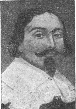
Of Tarapuhi, chief of the Mawhera Pa, the same author writes: “Tarapuhi was the most important chief on the West Coast in the sixties. He was far too important and of too high lineage to do any manual work. He might steer a canoe, but not carry a swag, and he always had two or three young men in attendance on him. He had a great reputation as an athlete and warrior, was over six feet in height, and a very well made muscular man of handsome countenance. I had no means of judging what his age was, but I should think that in 1864 he was probably about 70 years old, though very active and strong. His old wife, Mame, was always about with him, filling his pipe and brushing off the sandflies and mosquitoes, and always by his side in the whare. He died at Greymouth in April, 1864, while I was in Christchurch. He left Mame several important messages, which she was to give to me as soon as I returned. I found her in great grief at the loss of her husband. She said life was not worth living without Tarapuhi—he was the finest man in the world, and that she was only waiting for my return to give me his dying instructions. Then she would depart also. She then retired to the little whare which had been built for her to die in, refused all food, rolled herself up in her mats and blankets, and in a few days passed on.”
W. H. S. Hindmarsh, “Waratah,” who reached Old Westland in 1866, in “Tales of the Golden West,” devotes a chapter to Werita Tainui, brother of Tarapuhi, which contains much of great interest, and Tainui’s own story of the days before the coming of the Pakeha. This was translated from the Maori by John Greenwood, Native Agent at Greymouth, an accomplished Maori scholar, who had accompanied Bishop Selwyn on many of his historical journeys, thus gaining a wonderful knowledge of the language and customs of the Maori people. “Waratah” states: “Tainui was a Maori chief of the highest aristocratic caste, a good natured fellow of medium height and weight, with a bright face, showing the high caste Maori. His cheeks and chin were scored with the orthodox curve markings. He had an abundance of hair on his head, and his half-closed eyes had a merry twinkle in them. Anyone looking at him calmly could not have associated him with any of the atrocities or orgies of a Maori warrior of the ‘bad old days.’ . . . . His was a noble and warlike ancestry dating back into the dark ages, for the name Tainui is associated with the first canoes to reach New Zealand.”
Here follows Tainui’s own story: “In old times long ago, the West Coast was thickly peopled from the Buller to Okarito by the powerful tribe of Ngatiwairangi. Now it came to pass that being inspired with a thirst for glory, certain war parties crossed the mountains and made descents on the settlements of the Ngai-Tahu, who dwelt about Port Cooper (Lyttelton) and the Canterbury Plains. When victorious they enjoyed the fruits of conquest after preparing the same in Maori ovens. The Ngai-Tahu were not slow in returning the compliment, and thus an interchange of visits across the mountains was kept at the cost of much consumption of warriors; and many fights and great devastation ensued. In the long run the Port Cooper natives had the best of it, and the Ngatiwairangi were abolished, the land being occupied by five divisions of the Ngai-Tahu tribe. The original possessors of the Grey district were all wiped out by a war party under the leadership of my father, Tuhuru. I was only a little boy then. There was a great pa at the Ahaura. We attacked it and wasn’t there a slaughter! Those who got away fled to that high mountain you see at the back, but bless you, they were soon hunted down and knocked on the head! My father was something like a man. If we had been able to draw likenesses as you are, there would have been something for the Pakeha to look at. He was square built and at least eight feet high. Talk of Mr. Revell[1], pooh! He’s a baby to him. However, he died, and his bones are in that cave along by my house (the Mawhera Pa). My elder brother, Tarapuhi, is buried there also, and I live in my corner under the hill, keeping watch over those great men, my ancestors, who lie buried in the cave close by.”
In answer to a question how the war parties got across the mountains, Tainui said: “As for tracks for the war parties, they did without them; they simply followed up the Mawhera or some other river to its source, and then popped over the saddle, and followed a stream flowing the other way.”
A good, if grim story is told of Tainui who, as will be shown, was one of the chiefs who signed the “Deed of Sale of Westland.” When his title was being investigated, he was asked how he acquired the land he claimed, to which he replied that “his claim was uncontestable,” as he had eaten the former owner. The main thoroughfare running from Mawhera Quay to the southern boundary of Native Reserve 32, upon which the business portion of the town of Greymouth is built, perpetuates the name of Tainui. There is also a Werita Street and a Tarapuhi Street within the borough. Thus did John Rochfort when laying out Greymouth in 1865 honour the two last chiefs of the Mawhera Pa. Werita Tainui died at Greymouth and was buried with his ancestors under the hill. The Maoris after his death removed to the Arahura. Apart from the wars which were waged for greenstone, there were many petty disputes anent the right of taking native birds, kakapo, kiwi and weka in the Arahura, Hokitika, Grey and Buller districts. These disputes became more acute in the opening years of the 19th century, for at this time early sealing gangs were slaughtering these amphibious animals, which were to be found in their teeming thousands on certain beaches.
Tasman
In consequence of this a shortage of food was brought about, and tribal rights to have the sole occupation of certain localities for snaring purposes were jealously guarded and many minor clashes took place which led to some bloodshed, but as those concerned were few in number nothing very serious occurred. By 1838, however, the influence of the early missionaries was so great that from this date the natives, quick to learn, turned to more peaceful and profitable pursuits, and war was no more in Old Westland.
So much for mythology and conjecture. History tells us that Abel Janszoon Tasman, the famous Dutch navigator, discovered New Zealand, sighting the coast of Westland on December 13th, 1642, and it is this Province, therefore, that first stands sharply silhouetted on the horizon of Dominion history. Tasman quaintly described Westland as “a great land uplifted high, not unlike the island of Formosa with its piles of rugged mountains.” Employed by the Dutch East India Company, who were seeking new lands wherein to establish trading stations, Tasman at this time was endeavouring to ascertain whether New Holland, as Australia was then called, extended southward and formed a great Antarctic continent. He sailed from Batavia, on August 14th, 1642, in the Heemskercq, accompanied by the Zeehaen (the latter commanded by Gerritt Jansan), small vessels of 60 and 100 tons respectively. On November 24th of the same year he discovered and named Van Diemen’s Land, which we now know as Tasmania. One week later, on December 1st, he anchored in Fredrick Hendrik’s Bay (now Prince of Wales Bay), and took possession for Holland. Here he remained until December 9th, when he sailed east, and, as stated, picked up the coast of Westland four days later. He named the new country Staaten Land, as he considered it probably extended across the Pacific to what is now known as Staaten Island, south of Tierra del Fuego. Staaten Land, however, was soon afterwards proved by another explorer to be an island; thereupon the Dutch authorities changed the name of this country to New Zealand, though they did not reveal its existence to the world for some considerable time. Tasman sailed north along the West Coast until he rounded what we now call Farewell Spit, and anchored in what he called Murderers’ (now Golden) Bay. Here the Maoris attacked a boat’s crew and killed four of his men. He then sailed along the coast of the North Island (naming Cape Maria Van Diemen), until he rounded the North Cape, and on Epiphany Eve, some islets coming under his observation, he with due regard to the religious significance of the date of their discovery, named them the Three Kings in honour of the Wise Men from the East. This was his last act before departing, for the appearance of another band of Maoris so terrified him that he finally sailed away from this country without having set foot hereon, within a month of having first sighted “a great land uplifted high”—the shores of Old Westland.
Of the one hundred and twenty-eight years immediately following Tasman’s visit, nothing authentic is known of Westland’s history. Then Captain James Cook, on the occasion of his first voyage round the world in H.M.S. Endeavour, sailed along its shores and, sighting Aorangi, gave his own illustrious name to the mighty monarch of the Southern Alps. Cook was not impressed with Westland, which he described as “an inhospitable shore, unworthy of observation, except for its ridge of naked and barren rocks covered with snow. As far as the eye could reach the prospect was wild, craggy and desolate.”
Cook’s voyage was brought about by the fact that the Royal Society, in anticipation of the transit of Venus in 1769, decided that it was essential to despatch a properly equipped vessel, in command of a competent officer, to the South Seas for observation purposes, Cook being selected to lead the expedition on account of being an acknowledged authority in mathematics and astronomy. He was also instructed to clear up the mystery pertaining to the geography of the Pacific Ocean, especially in the south, by proceeding in that direction as far as latitude 40°. If he found no land he was to sail westward until he reached New Zealand, which was to be thoroughly explored and reported upon.
It was in the carrying out of these instructions, therefore, that on October 7th, 1769, he sighted land in the vicinity of Poverty Bay, anchoring therein two days later. Having completed his survey of the North Island and taken possession of it in the name of the King, he sailed southward to Ship Cove, Queen Charlotte Sound, not realising he was in another island. Here necessary repairs were carried out, and he from a nearby hill saw the strait which now bears his name, and realised for the first time that New Zealand consisted of two separate islands. After again taking possession in the name of the King, he sailed down the East Coast, being uncertain whether Banks Peninsula might not be an island. Continuing his voyage he rounded Stewart Island, but failed to discover Foveaux Strait. Standing in again to the southern portion of the West Coast, he observed what he considered to be a large well sheltered natural harbour, but did not attempt to enter owing to the approach of night and bad visibility. This potential anchorage which he named Dusky Bay was to become, only twenty-three years later, world famous as the centre of the sealing industry. Proceeding north, he in due course reached Queen Charlotte Sound again, prior to which he sailed along the coast of, and commented, as aforesaid, on the “inhospitable shores” of Old Westland.
- ↑ William Horton Revell, known as “Big” Revell, the outstanding personality of Old Westland’s golden age.