APPENDIX.
STATISTICAL TABLES.
TRIPOLITANA.
| Area, including the Kufra Oasis
|
485,000
|
sq. miles
|
| Population, according to Behm and Wagner
|
1,010,000
|
|
| Area of Barka, excluding the Southern oases
|
20,000
|
sq. miles
|
| Approximate population, according to Camperio
|
246,000
|
|
|
Area.
|
|
Population.
|
Date-palms.
|
|
| Aujila
|
8
|
sq. miles
|
(?)
|
4,000
|
40,000
|
|
| Jalo
|
80
|
"
|
(?)
|
6,000
|
100,000
|
|
| Wadi
|
80
|
"
|
(?)
|
1,080
|
40,000
|
(?)
|
| Leshkerreh
|
4
|
"
|
(?)
|
500
|
20,000
|
(?)
|
| Area according to Bohm.
|
| Taiserbo
|
2,536
|
sq. miles
|
| Sirhen
|
820
|
"
|
| Buseima
|
125
|
"
|
| Erbehna
|
126
|
"
|
| Kebabo
|
3,500
|
"
|
| Total
|
7,105
|
"
|
Palm Groves of Tripolitana.
| Meshiya of Tripoli,
|
according
|
to Barth
|
1,000,000
|
palms
|
| Plantations
|
of Zawya
|
"
|
"
|
130,000
|
"
|
| "
|
of Zenzur
|
"
|
to Rohlfe
|
100,000
|
"
|
| "
|
of Tajura
|
"
|
"
|
200,000
|
"
|
| Oasis of Zella
|
"
|
"
|
100,000
|
"
|
| "
|
of Jofra
|
"
|
"
|
15,000
|
"
|
| Misda and Gharia
|
"
|
"
|
1,000
|
"
|
| Other plantations
|
100,000(?)
|
"
|
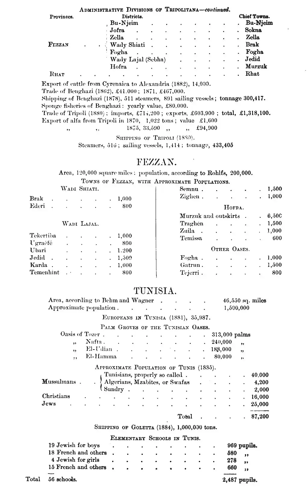
Administrative Divisions of Tripolitana.
| Provinces.
|
|
Districts.
|
Chief Towns.
|
| Barka
|

|
Jebel-el-Akabah
|
Derna
|
| Jebel-el-Akhdar
|
Benghazi
|
| Aujila Oasis
|
Aujila
|
| Jalo Oasis
|
Lebba
|
| Leshkerreh Oasis
|
——
|
| Tripoli
|
|
Tripoli
|
Tripoli
|
| Zawya
|
Zawya
|
| Khoms
|
Lebda
|
| Jebel
|
Kazr-el-Jebel
|
| Ghadames
|
Ghadames
|